ClockBoard: A zoning system for urban analysis
DOI:
https://doi.org/10.5311/JOSIS.2022.24.172Keywords:
zoning, areal data, zoning systems, modifiable area unit problemAbstract
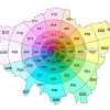
Zones are the building blocks of urban analysis. Fields ranging from demographics to transport planning routinely use zones - spatially contiguous areal units that break-up continuous space into discrete chunks - as the foundation for diverse analysis techniques. Key methods such as origin-destination analysis and choropleth mapping rely on zones with appropriate sizes, shapes and coverage. However, existing zoning systems are sub-optimal in many urban analysis contexts, for three main reasons: 1) administrative zoning systems are often based on somewhat arbitrary factors; 2) zoning systems that are evidence-based (e.g., based on equal population size) are often highly variable in size and shape, reducing their utility for inter-city comparison; and 3) official zoning systems in many places simply do not exist or are unavailable. We set out to develop a flexible, open and scalable solution to these problems. The result is the zonebuilder project (with R, Rust and Python implementations), which was used to create the ClockBoard zoning system. ClockBoard consists of 12 segments emanating from a central place and divided by concentric rings with radii that increase in line with the triangular number sequence (1, 3, 6 km etc). 'ClockBoards' thus create a consistent visual frame of reference for monocentric cities that is reminiscent of clocks and a dartboard. This paper outlines the design and potential uses of the ClockBoard zoning system in the historical context, and discusses future avenues for research into the design and assessment of zoning systems.
Downloads
Published
Issue
Section
License
Copyright (c) 2022 Robin Lovelace, Martijn Tennekes, Dustin Carlino

This work is licensed under a Creative Commons Attribution 3.0 Unported License.
Articles in JOSIS are licensed under a Creative Commons Attribution 3.0 License.
