Surface network extraction from high resolution digital terrain models
Keywords:
digital terrain modeling, digital elevation model, surface network, Morse-Smale complex, thalweg, ridge, data structure, geomorphometryAbstract
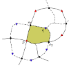
A surface network is a topological data structure formed by a set of thalwegs and ridges on a digital terrain model. Its computation relies on the detection of saddles on the terrain. Hence, computation methods must guarantee enough saddles are detected but also that no improper conflicts between ridges and thalwegs are created, leading to an inconsistent network. This paper presents a new approach that maximizes the number of saddles and ensures this topological consistency for high-resolution terrain models represented by a raster grid. The grid is triangulated in order to preserve saddles and to facilitate thalweg and ridge computation. It does not require any user parameter and lines remain aligned with triangulation edges, avoiding numerical errors. The method also includes a coherent partitioning of the terrain into hills and dales. A case study shows that the surface network computation can be achieved in reasonable time and hence can be applied to the analysis of large terrain models.
Downloads
Published
Issue
Section
License
Copyright (c) 2021 Eric Guilbert

This work is licensed under a Creative Commons Attribution 3.0 Unported License.
Articles in JOSIS are licensed under a Creative Commons Attribution 3.0 License.
