VGI in surveying engineering: Introducing collaborative cloud land surveying
Keywords:
volunteered geographic information, engineering applications, spatial data, service sharing, collaborative cloud land surveyingAbstract
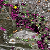
Volunteered geographic information (VGI) has enabled many innovative applications in various scientific fields. This paper introduces a new framework called "collaborative cloud-based land surveying" (CCLS) that uses VGI principles for data sharing among surveyor engineers to boost the productivity and improve the quality of their applications. A cloud-based spatio-temporal data repository is presented, aiming to facilitate the sharing of VGI among surveyor engineers. A fully-functional distributed software application has been developed and used to apply CCLS in a large-scale land surveying project run by the Greek Ministry of Culture, which involves the mapping of the historic center of Athens. Results from the data analysis of hundreds of measurements indicate a substantial (30% to 60%) error reduction and also a significant productivity raise (~22%). The collected measurements are shared in an online database, accessible by professional surveyors who can in turn contribute their own data to further enhance the CCLS system.
Downloads
Published
Issue
Section
License
Copyright (c) 2017 Ioannis Sofos, Vassilios Vescoukis, Maria Tsakiri

This work is licensed under a Creative Commons Attribution 4.0 International License.
Articles in JOSIS are licensed under a Creative Commons Attribution 3.0 License.
