Automatic integration of spatial data in viewing services
Keywords:
SDI, geoportals, cartography, expert system, geometrical inconsistency, topological conflicts, semantic labeling, conflationAbstract
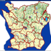
Geoportals are increasingly used for searching, viewing, and downloading spatial data. This study concerns methods to improve the visual presentation in viewing services. When spatial data in a viewing service are taken from more than one source there are often syntactic, semantic, topological, and geometrical conflicts that prevent maps being fully consistent. In this study we extend a standard view service with methods to solve these conflicts. The methods are based on: (1) semantic labels of data in basic services, (2) a rule-base in the portal layer, and (3) integration methods in the portal layer. To evaluate the methodology, we use a case study for adding historical borders on top of a base-map. The results show that the borders are overlaid on top of the map without conflicts, and that a consistent map is generated automatically as an output. The methodology can be generalized to add other types of data on top of a base-map.
Downloads
Published
Issue
Section
License
Copyright (c) 2013 Ara Tooamnian, Lars Harrie, Ali Mansourian, Petter Pilesjo

This work is licensed under a Creative Commons Attribution 4.0 International License.
Articles in JOSIS are licensed under a Creative Commons Attribution 3.0 License.
